GamblingWithThePast
A Remote Sensing Assessment of Gamble Plantation
Major Robert Gamble founded Gamble Plantation on 160 acres along the Manatee River in the mid-1840s. By 1850 his holdings expanded to include 3,500 acres and over 200 enslaved individuals. Today, a portion of what was once the plantation is a State Park.
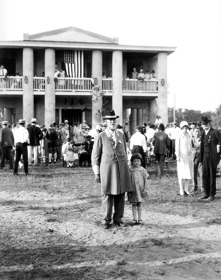
Confederate Reunion, 1927 Photo courtesy of Gamble Plantation Historic State Park.
The park consists of the antebellum plantation house, a small museum, and a few other related features. Noticeably absent from the property, however, are the quarters where the enslaved Africans working the planation would have lived.
These enslaved African domestic sites have yet to be located and uncovered by archaeologists or historians. This is unfortunate, because a lack of archaeological information about the daily lives of the enslaved at Gamble can lead to a skewed perception of history that ignores the cultural heritage of African Americans.
Research Goals
Currently, there are no known historical documents that explicitly state the location of the living quarters of those enslaved at Gamble Plantation. Based on similar plantations in Florida, we believe the quarters would have been in the general vicinity of the plantation house.
In archaeological investigations, it is customary to perform a ground survey on foot to assess if an area would be ideal to excavate. However, because the area we are interested in is both expansive and largely developed, ground survey would not be the most effective way to identify potential excavation sites.
Therefore, we hypothesize that we will be able to use LiDAR data to identify potential areas of slave domestic sites. Once these areas are identified, archaeological investigation can be conducted to either confirm or deny the presence of slave quarters.
What is LiDAR?!
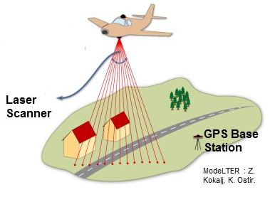
Light Detection and Ranging (LiDAR) is a system of remote sensing. A plane equiped with a LiDAR sensor flies over an area and uses a laser to discharge light towards the ground. This light bounces off of things like trees and buildings before it is reflected back to the LiDAR sensor and recorded. The sensor also communicates with satellites to assign a GPS location for each data set.
Based on the time it takes for the light to reflect back to the sensor, we are able to understand what kinds of structures or vegetation are present, and determine the elevation of an area.
Why is LiDAR important to archaeologists?
LiDAR is increasingly important in archaeology because it allows archaeologists to visualize areas that are inaccessible.
It’s also helpful because it allows us to see features that might not be visible with the naked eye. Light from the laser is able to penetrate through foliage, to reveal information about the underlying ground surface.
What We’ve Found So Far
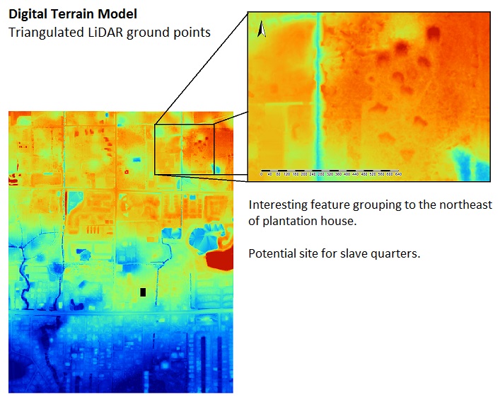
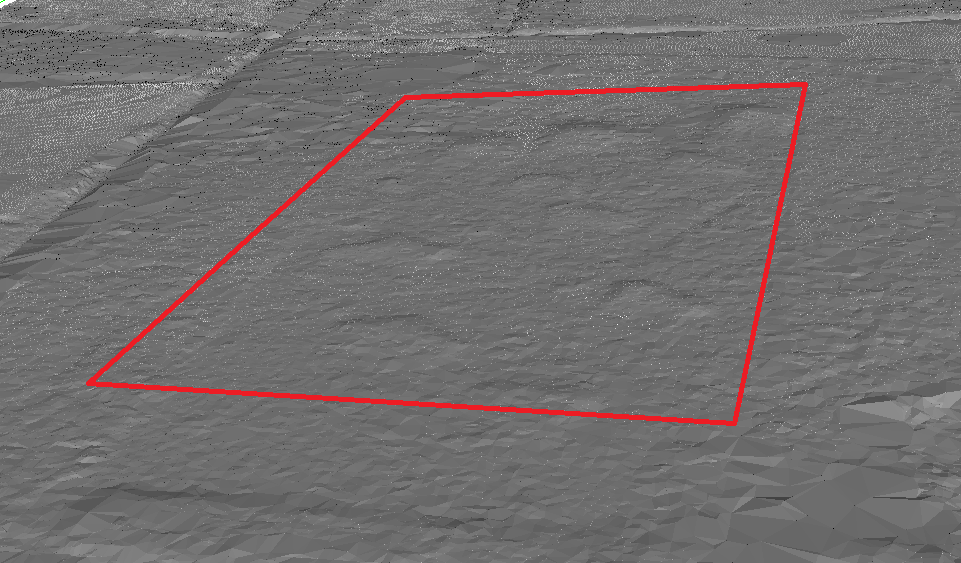
This basic LiDAR image highlights an area of interest to the northeast of the Gamble plantation house. In what seems to be an undeveloped field, we’ve identified several circular features measuring about 40ft across and 1 to 2 feet high. These are the right shape and size to potentially be remnants of slave quarters. You can use the 3D point cloud below to take a closer look at the area.
To get a better view of the elevation on these potential features, we also made a profile of the area, which allows us to view the ground as if we were standing nearby.
Next, to make sure there weren’t any classification errors in our LiDAR visual, in which vegetation (like trees) could be confused with ground points, we created a visualization of all points reflected back to the sensor.
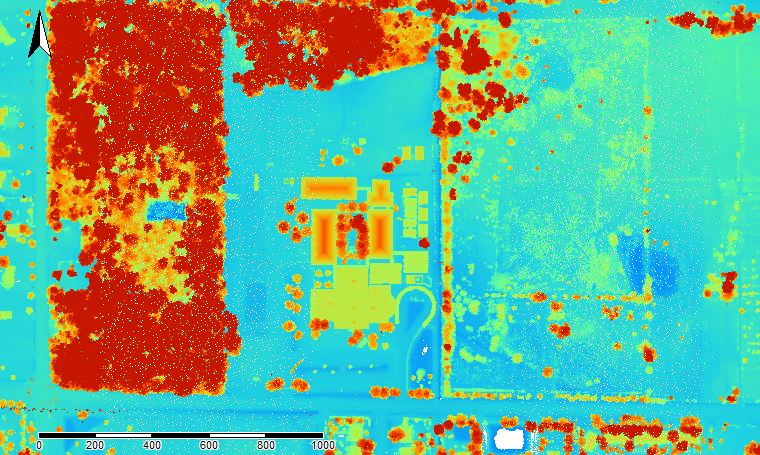
In this image, the red areas indicate vegetation (i.e. trees, bushes, etc.) Since there is no red in the area of interest, we have determined that these features are not trees.
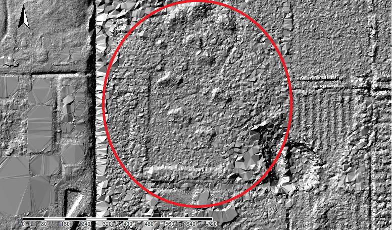
To get an even better understanding of these features, we created an image called a hillshade. This type of visualization shows an area as if the sun was shining from a specified angle overhead, which adds shadow and allows us to see areas of interest in more detail.
Finally, we wanted to see if there were any modern structures previously in the area that could have left behind these features. To do this, we looked at historic aerial photos of the area over the past 75 years. We were also able to identify the features in nearly all of the historic aerial photos.
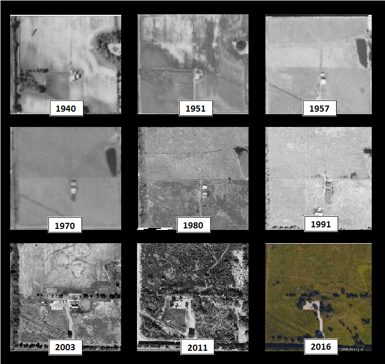
Because the features we are interested in are visible as far back as 1951, coupled with the fact that the aerial photos show no structures in this area since 1940, we conclude that the features must have been created prior to 1940. Making these features good candidates for potential slave quarters.
What Finding the Slave Quarters Would Mean
LiDAR visualizations can tell us about the community organization patterns of the enslaved. These features have a rather organic spatial arrangement, which may provide clues about the cultural identity and agency of the enslaved. The visualizations can also open up the door to archaeological excavation, which will allow us to better understand the daily lives of enslaved Africans at Gamble.
Additionally, since the museum at Gamble Plantation Historic State Park does not currently include a heavy narrative about the enslaved, slave quarter excavations could supply key information that would lead to African-American heritage finally being represented at the museum.
Is Your Home a Piece of Gamble History?!
Do you live in the area around Gamble Plantation? Have you ever found artifacts or old foundations on your property? Does your land have a unique history?
If you answered yes to any of these questions, we want to hear from you! Send us an email at the address listed below - we’d love to learn about your property and potentially schedule a walkthrough of your land.
About The Authors


Matt Litteral and Kate Padula are Master’s Candidates in Applied Anthropology at the University of South Florida. They are both in the archaeology track, studying sugar plantations in Florida.
Contact Us
If you are interested in learning more about this project, or have any information you think would help in our research, please contact Matt Litteral at smlitteral@mail.usf.edu.
Data sources: noaa
2007 FDEM Lidar: Southwest Florida Southwest FL Water Management District, FL Division of Emergency Management, FL Fish and Wildlife Conservation Commission, FL Department of Environmental Protection
http://ufdc.ufl.edu/aerials